Infrastructure-free deployment
Designed to use wireless signals already present in the environment together with endpoint sensing capabilities, without requiring venues to install dedicated positioning hardware.
Spatial Intelligence for Humans and Machines
Inkwater Last-Meter Positioning is designed to extend location awareness from outdoor satellite navigation into airports, stations, commercial complexes and other GPS-denied environments.

The Last Meter
GPS and GNSS have transformed outdoor navigation. Yet satellite signals can deteriorate rapidly inside airports, shopping centers, hospitals, factories, underground parking structures, tunnels and large transportation hubs.
Inkwater defines Last-Meter Positioning as the missing positioning layer between outdoor GPS and indoor or other GPS-denied environments, with a path toward continuous Spatial Intelligence in three-dimensional physical space.
Explore Deeper
How Inkwater packages Last-Meter Positioning as a Spatial Intelligence platform for venues, devices and machines.
Open sectionTechnologyA deeper view of the signal layer, sensor fusion, X/Y/Z inference and self-optimizing architecture.
Open sectionApplicationsHow Last-Meter Positioning may support airports, malls, hospitals, factories, robotics, safety and mobility.
Open sectionDeploymentsReal-world proof points across Changi Airport, Tokyo Station and major commercial complexes in China.
Open sectionPartnersPartnership paths for mapping platforms, robotics companies, venue operators, mobility and safety providers.
Open sectionDesigned to use wireless signals already present in the environment together with endpoint sensing capabilities, without requiring venues to install dedicated positioning hardware.
Built to reduce dependence on repeated manual fingerprint collection, allowing positioning performance to improve as real-world usage and environmental data accumulate.
Extends beyond two-dimensional location to help identify the right floor or vertical level across multi-level buildings, roads, stations and commercial spaces.
Platform Model
Transforms ambient signals, endpoint sensing and spatial association into a GPS-denied location layer.
Connects X/Y/Z location context to floors, zones, corridors, entrances, parking areas and vertical transitions.
Uses repeated real-world observations to refine positioning performance and reduce recurring calibration burden.
Frames future services for child safety, elder safety, staff workflows and emergency response in GPS-denied spaces.
AI Engine Demo
The Inkwater platform story now includes a clearer animated model of how Wi-Fi, 5G, Bluetooth, UWB and endpoint sensing converge through one AI core before becoming indoor X/Y/Z positioning, floor awareness and route context. View the platform explanation.
How It Works
Use wireless signals already present in the venue, together with endpoint sensor inputs, as the environmental reference layer.
Translate signal and sensing observations into horizontal position and floor-level awareness for complex indoor and GPS-denied spaces.
Improve positioning performance as real-world observations accumulate, reducing dependence on recurring manual fingerprint surveys.
Why No Beacon Matters
Inkwater's strategy is not only about accuracy. It is about reducing the infrastructure, maintenance and recalibration burden that has historically slowed broad adoption of indoor and GPS-denied positioning.
Can require venue-by-venue hardware installation, battery maintenance and ongoing operational management.
Can deliver precision, but often require dedicated infrastructure, installation planning and higher deployment cost.
Can depend on repeated site surveys, map association and recalibration as RF environments change.
Works well outdoors, but cannot reliably carry people, vehicles or robots through indoor, underground and obstructed environments.
Technical Architecture
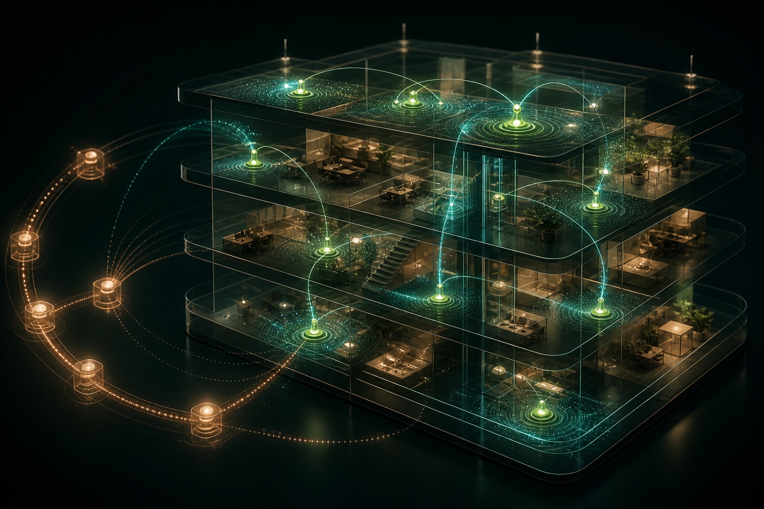
The architecture is designed to transform existing environmental signals and endpoint sensing into a location layer that can support navigation, floor-level awareness and future machine spatial intelligence.
As deployments scale, the learning loop can use real-world positioning observations to improve performance and reduce the cost of maintaining accuracy over time.
"GPS changed the way humanity understands location, but it did not complete the last meter of positioning."
I-Fa Chang, Chairman, Inkwater Holding Inc.
Why Now
Outdoor navigation has become universal, yet the user journey often breaks inside airports, stations, malls, hospitals, parking structures and underground spaces.
Humanoid robots, AMRs and autonomous equipment need to understand where they are before they can reason about what is nearby or what to do next.
Beacon-first approaches can become hardware projects. Infrastructure-free positioning creates a more practical path for large operators and platforms.
Market Direction
Global maps and location services
Physical AI and humanoid robotics
Airports, hospitals, factories and malls
Smart mobility and low-altitude economy
Location Safety for children and older adults
GPS-denied, underground and dual-use environments
Physical AI question stack
Partnership Packages
Evaluate GPS-denied positioning in airports, stations, malls, hospitals, campuses, factories or parking structures.
Explore how Last-Meter Positioning can support humanoids, AMRs and embodied AI systems operating around people.
Extend outdoor navigation into the indoor, underground and obstructed environments where users still need continuity.
Develop safety-oriented services for children, older adults, staff, emergency response and vulnerable-location workflows.
Applications

Guide passengers, staff and assets through terminals, platforms, concourses, parking structures and transfer paths.
Enable indoor navigation, customer flow intelligence, parking-to-store guidance and large venue operations.
Support Location Safety, staff workflows, patient movement and emergency response in buildings where GPS is unreliable.
Help autonomous equipment, workers and assets maintain spatial awareness across dense industrial environments.
Give mobile machines a positioning layer before they decide where to go, what is around them and what to do next.
Explore continuity for drones, autonomous mobility platforms and GPS-denied operations near buildings and infrastructure.
Deployment Proof
Multi-level transportation, terminal and passenger movement complexity.
Dense transit flows, underground paths and challenging vertical-position context.
Large indoor retail and mixed-use spaces where GPS cannot support precise last-meter navigation.
Buyer Video References
"What excites me most about the Last-Meter technology Inkwater is advancing is that it does not require every venue to redeploy beacons or install dedicated positioning hardware. Just as importantly, positioning error can be continuously optimized, allowing the system to improve as it is used."
Dr. Jiangsen Tian, Chief AI Scientist, Yushan AI
"We see not only an indoor positioning market, but the unresolved last meter after GPS."
Allen Chiu, Head of Business Development, Inkwater
Location Safety
Continuous positioning from outdoor GPS into indoor and GPS-denied spaces may support future safety services for children, older adults, emergency response and other situations where the moment someone most needs to be found may be the same moment GPS can no longer find them.
Corporate Ecosystem
Docter Inc. is a wholly owned company under Inkwater Holding Inc., supporting the broader technology and commercial ecosystem.
Visit docter.oneFAQ
No. The strategy is to complement GPS by extending positioning continuity into environments where satellite signals become weak, blocked or unavailable.
The core positioning strategy is designed around No GPS, No Beacon and No New Infrastructure, using signals already present in the environment and endpoint sensing capabilities.
The technology direction includes X/Y/Z spatial awareness, because determining the correct level can be as important as horizontal location in airports, stations, malls and parking structures.
No. Inkwater frames the opportunity as GPS-denied positioning and Spatial Intelligence, spanning indoor, underground, obstructed, robotics, mobility, safety and selected dual-use environments.
Inkwater is open to strategic discussions with mapping platforms, robotics companies, venue operators, mobility providers, infrastructure owners and safety-service partners.
Press & News
Infrastructure-free, self-optimizing positioning requires no beacons or dedicated positioning hardware.
Inkwater defines Last-Meter Positioning as the missing layer between satellite navigation and indoor or GPS-denied spaces.
The company is exploring strategic relationships across mapping, robotics, intelligent mobility, safety and infrastructure.
Media Pickup
Chinese Media Coverage
Partnership CTA
For enterprise, infrastructure, robotics, mapping, mobility and strategic partnership discussions, contact the Inkwater team.
Address221 W 9th St, PMB 235, Wilmington, Delaware 19801
Phone+1 425-365-9666